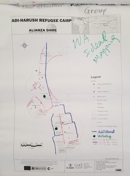
Community Participatory Mapping in refugee camps

Last October, from Aliana Shire we organized 15 “Community Participatory Mapping” workshop with the participation of more than 100 people from the four refugee camps we are working in.
The objective was to define the best location for the lighting and power grids in those camps by designing a series of maps that could later be used to make decisions about the project.
During the workshops, refugees identified the areas, routes and priority points for lighting. This way, the diversity of participants and perceptions was sought.
Participating groups were the women’s association, groups of unaccompanied minors, the Refugee Central Committee (RCC) and other relevant organizations from each camp.
To encourage and maintain an atmosphere of openness and trust for the exchange of information, it was decided to treat each of the groups in an individual workshop.
The methodology was divided into three steps:
- Our partner organization in the camps, ZOA, developed the workshops with each group and in each camp, identifying on the map the current safety related problems resulting from the absence of lighting. Possible solutions to these problems were then proposed.
- ItdUPM and the technical staff were responsible for contrasting the information from the different workshops to find any existing patterns or consensus among the perceptions and priorities of all the participating groups in each camp.
- Finally, itdUPM and the technical staff contrasted these maps with the existing project design, budget and technical characteristics to develop a plan to connect the identified priority areas.
The result was presented in a final map so that all groups that participated in the workshops could comment or provide additional information.
The most recurrent problems
Sexual assault, harassment, theft and robbery, fear, feelings of insecurity, conflict and livelihood issues, such as the inability to perform certain jobs, were the most recurrent security problems identified.
During the systematization of the maps, the team discovered several patterns in the location of the mentioned problems. Among them:
- The border areas of the fields and the roads leading to the host communities as often problematic routes.
- Latrines, kitchens or communal services, and certain streets have been identified as trouble spots. Commercial areas outside the main roads have also been identified as dangerous. Further analysis is needed to understand the behaviors that cause insecurity at these points.
- Main roads. Although these roads have not been identified as problem points, most groups have indicated the importance of installing lighting on them to meet other objectives such as promoting livelihood activities and increasing the quality of life.


